Division of Kingston
| Kingston Australian House of Representatives Division | |
|---|---|
Map Interactive map of boundaries | |
| Created | 1949 |
| MP | Amanda Rishworth |
| Party | Labor |
| Namesake | Charles Kingston |
| Electors | 124,582 (2022) |
| Area | 171 km2 (66.0 sq mi) |
| Demographic | Outer metropolitan |
The Division of Kingston is an Australian Electoral Division in South Australia covering the outer southern suburbs of Adelaide. The 171 km2 seat stretches from Hallett Cove and O'Halloran Hill in the north to Maslin Beach in the south, including the suburbs of Aberfoyle Park, Christie Downs, Christies Beach, Flagstaff Hill, Hackham, Hallett Cove, Huntfield Heights, Lonsdale, Maslin Beach, Moana, Morphett Vale, Old Noarlunga, Onkaparinga Hills, Port Noarlunga, Reynella, Seaford, Sheidow Park, Port Willunga, Trott Park, Woodcroft, and parts of Happy Valley and McLaren Flat.
History
[edit]
The division was named after Charles Kingston, Premier of South Australia (1893–1899), elected to the first House of Representatives in 1901 and the first Federal member of the Division of Adelaide in 1903. Kingston was first based on the Holdfast Bay area to the north of the current boundaries from the 1949 election as a notionally marginal to fairly safe Labor seat. However, it fell to the Liberals in that election, only to have Labor win it at the 1951 election. This started a tradition of Labor and the Liberals alternating for long spells in a seat that has slowly moved south over the decades. It has now moved almost clear of its original boundaries; Hallett Cove is the only suburb within the seat's current borders that was part of the seat in 1949.
It has tended to elect an MP from the governing party of the day, having elected only four opposition MPs. Notably, every sitting member in the electorate's history has been defeated at the polls—none have retired or resigned.[1]
Kingston has been represented by Labor MP Amanda Rishworth since the 2007 election where she won with a 54.4 percent two-party vote from a 4.5 percent swing. Going into the 2010 election, it was the most marginal Labor seat in South Australia. However, Rishworth consolidated her hold on the seat in 2010 by winning a 64 percent two-party vote from a 9.5 percent swing. At the 2013 election, Rishworth suffered a 4.9 percent swing to finish on a 59.7 percent two-party vote, but was still the second largest vote of any party in Kingston's history. In 2016, Rishworth further strengthened her hold on Kingston by boosting her majority to 67.1 percent on a swing of 7.7 percent, the strongest result in the seat's history. It is now Labor's second-safest seat in South Australia, behind only Port Adelaide, on two-party terms, however on the primary vote Kingston polled one percent higher at over 49 percent, the highest primary vote of South Australia's 11 seats. Though Labor picked up a two-party swing in all eleven seats, the presence of Nick Xenophon Team candidates in all eleven seats produced, apart from a suppressed major party primary vote, a result where Rishworth was the only major party candidate in the state to pick up a primary vote swing.
Redistributions
[edit]
Kingston began to move south from 1969 when the Holdfast Bay area was transferred to the newly created seat of Hawker. Successive redistributions saw Hawker continue to push Kingston south over time, and by 1984 the seat had moved to roughly its current position, though without the current southern coastal strip.[2]
Since 1984, federal electoral division boundaries in Australia have been determined at redistributions by a redistribution committee appointed by the Australian Electoral Commission. Redistributions occur for the boundaries of divisions in a particular state, and they occur every seven years, or sooner if a state's representation entitlement changes or when divisions of a state are malapportioned.[3]
The redistribution before the 2013 election removed Kingston's rural areas with the transfer of around 6,500 voters in McLaren Vale and Willunga to Mayo, increasing Labor's Kingston margin by half a percent.[4] This substantially reduced the area covered by the electorate, down from 377 to 171 square kilometres, almost the same as the 2001 to 2004 boundaries.[5] The previous larger boundaries were used from 2004 to 2013 and loosely from 1993 to 1998.
Members
[edit]| Image | Member | Party | Term | Notes | |
|---|---|---|---|---|---|
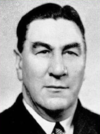
|
Jim Handby (1903–1991) |
Liberal | 10 December 1949 – 28 April 1951 |
Lost seat | |
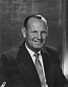
|
Pat Galvin (1911–1980) |
Labor | 28 April 1951 – 26 November 1966 |
Lost seat | |
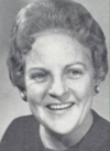
|
Kay Brownbill (1914–2002) |
Liberal | 26 November 1966 – 25 October 1969 |
Lost seat | |

|
Richard Gun (1936–) |
Labor | 25 October 1969 – 13 December 1975 |
Lost seat | |

|
Grant Chapman (1949–) |
Liberal | 13 December 1975 – 5 March 1983 |
Lost seat. Later elected to the Senate in 1987 | |

|
Gordon Bilney (1939–2012) |
Labor | 5 March 1983 – 2 March 1996 |
Served as minister under Hawke and Keating. Lost seat | |

|
Susan Jeanes (1958–) |
Liberal | 2 March 1996 – 3 October 1998 |
Lost seat | |

|
David Cox (1954–) |
Labor | 3 October 1998 – 9 October 2004 |
Lost seat | |

|
Kym Richardson (1958–) |
Liberal | 9 October 2004 – 24 November 2007 |
Lost seat | |
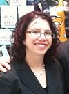
|
Amanda Rishworth (1978–) |
Labor | 24 November 2007 – present |
Incumbent. Currently a minister under Albanese |
Election results
[edit]| Party | Candidate | Votes | % | ±% | |
|---|---|---|---|---|---|
| Labor | Amanda Rishworth | 53,810 | 49.20 | −1.38 | |
| Liberal | Kathleen Bourne | 28,273 | 25.85 | −5.87 | |
| Greens | John Photakis | 13,603 | 12.44 | +3.24 | |
| One Nation | Robert Godfrey-Brown | 5,313 | 4.86 | +4.86 | |
| United Australia | Russell Jackson | 4,321 | 3.95 | −1.02 | |
| Independent | Rob De Jonge | 2,963 | 2.71 | +2.71 | |
| Federation | Sam Enright | 1,079 | 0.99 | +0.99 | |
| Total formal votes | 109,362 | 96.19 | +0.30 | ||
| Informal votes | 4,336 | 3.81 | −0.30 | ||
| Turnout | 113,698 | 91.37 | −1.80 | ||
| Two-party-preferred result | |||||
| Labor | Amanda Rishworth | 72,564 | 66.35 | +4.41 | |
| Liberal | Kathleen Bourne | 36,798 | 33.65 | −4.41 | |
| Labor hold | Swing | +4.41 | |||
See also
[edit]References
[edit]- ABC profile for Kingston: 2016
- Poll Bludger profile for Kingston: 2016
- AEC profile for Kingston: 2016
Notes
[edit]- ^ Munro, Ian (26 July 2010). "Labor incumbent looks safe in see-saw seat". The Sydney Morning Herald. Fairfax Media. Retrieved 4 January 2011.
- ^ SA boundary map, 1984: Atlas SA Archived 2016-03-10 at the Wayback Machine
- ^ Muller, Damon (14 November 2017). "The process of federal redistributions: a quick guide". Parliament of Australia. Retrieved 19 April 2022.
- ^ ABC profile for Kingston: 2013
- ^ SA boundary map, 2001: AEC
- ^ Kingston, SA, 2022 Tally Room, Australian Electoral Commission.


