Oshamambe, Hokkaido
Appearance
Oshamambe
長万部町 | |
|---|---|
Town | |
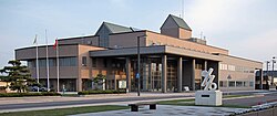
 Oshamanbe Town Hall | |
 Location of Oshamambe in Hokkaido (Oshima Subprefecture) | |
| Coordinates: 42°30′29″N 140°22′23″E / 42.50806°N 140.37306°E | |
| Country | Japan |
| Region | Hokkaido |
| Prefecture | Hokkaido (Oshima Subprefecture) |
| District | Yamakoshi |
| Government | |
| • Mayor | Masashi Kihata |
| Area | |
| • Total | 310.75 km2 (119.98 sq mi) |
| Population (30 September 2016) | |
| • Total | 5,694 |
| • Density | 18/km2 (47/sq mi) |
| Time zone | UTC+09:00 (JST) |
| City hall address | 453-1 Oshamambe, Oshamambe, Yamakoshi District, Hokkaido 049-3592 |
| Climate | Dfb |
| Website | www |
| Symbols | |
| Flower | Iris sanguinea |
| Tree | Pinus thunbergii |
Oshamambe (長万部町, Oshamambe-chō) is a town located in Oshima Subprefecture, Hokkaido, Japan.
As of 30 October 2016, the town has an estimated population of 5,694. The total land area is 310.75 km2.
Geography
[edit]Oshamambe faces Uchiura Bay, which is a bay of the Pacific Ocean.
Neighboring municipalities
[edit]- Hiyama Subprefecture
- Iburi Subprefecture
- Oshima Subprefecture
- Shiribeshi Subprefecture
Climate
[edit]| Climate data for Oshamambe, Hokkaido (1991−2020 normals, extremes 1977−present) | |||||||||||||
|---|---|---|---|---|---|---|---|---|---|---|---|---|---|
| Month | Jan | Feb | Mar | Apr | May | Jun | Jul | Aug | Sep | Oct | Nov | Dec | Year |
| Record high °C (°F) | 8.1 (46.6) |
9.1 (48.4) |
16.0 (60.8) |
23.8 (74.8) |
29.3 (84.7) |
29.9 (85.8) |
32.6 (90.7) |
32.0 (89.6) |
30.8 (87.4) |
25.4 (77.7) |
20.4 (68.7) |
13.3 (55.9) |
32.6 (90.7) |
| Mean daily maximum °C (°F) | −0.2 (31.6) |
0.4 (32.7) |
4.0 (39.2) |
9.9 (49.8) |
14.9 (58.8) |
18.3 (64.9) |
22.1 (71.8) |
24.2 (75.6) |
22.0 (71.6) |
16.1 (61.0) |
8.7 (47.7) |
2.0 (35.6) |
11.9 (53.4) |
| Daily mean °C (°F) | −4.1 (24.6) |
−3.6 (25.5) |
0.0 (32.0) |
5.2 (41.4) |
10.2 (50.4) |
14.5 (58.1) |
18.7 (65.7) |
20.6 (69.1) |
17.2 (63.0) |
10.7 (51.3) |
4.1 (39.4) |
−1.9 (28.6) |
7.6 (45.8) |
| Mean daily minimum °C (°F) | −8.7 (16.3) |
−8.6 (16.5) |
−4.6 (23.7) |
0.3 (32.5) |
5.6 (42.1) |
11.1 (52.0) |
15.9 (60.6) |
17.4 (63.3) |
12.6 (54.7) |
5.4 (41.7) |
−0.5 (31.1) |
−6.1 (21.0) |
3.3 (38.0) |
| Record low °C (°F) | −20.5 (−4.9) |
−20.4 (−4.7) |
−16.6 (2.1) |
−9.7 (14.5) |
−2.1 (28.2) |
2.7 (36.9) |
5.2 (41.4) |
7.4 (45.3) |
2.2 (36.0) |
−3.0 (26.6) |
−10.4 (13.3) |
−18.9 (−2.0) |
−20.5 (−4.9) |
| Average precipitation mm (inches) | 73.2 (2.88) |
73.3 (2.89) |
64.3 (2.53) |
82.2 (3.24) |
104.7 (4.12) |
98.4 (3.87) |
148.1 (5.83) |
176.2 (6.94) |
164.5 (6.48) |
114.6 (4.51) |
108.0 (4.25) |
88.8 (3.50) |
1,296.1 (51.03) |
| Average snowfall cm (inches) | 174 (69) |
164 (65) |
104 (41) |
9 (3.5) |
0 (0) |
0 (0) |
0 (0) |
0 (0) |
0 (0) |
0 (0) |
24 (9.4) |
128 (50) |
600 (236) |
| Average rainy days | 16.9 | 16.0 | 13.6 | 11.0 | 10.2 | 9.5 | 11.1 | 11.3 | 11.6 | 13.2 | 15.3 | 16.5 | 156.2 |
| Average snowy days | 21.6 | 20.4 | 15.0 | 1.4 | 0 | 0 | 0 | 0 | 0 | 0 | 3.0 | 15.7 | 77.1 |
| Mean monthly sunshine hours | 98.0 | 95.7 | 141.6 | 174.3 | 179.8 | 135.2 | 113.5 | 131.9 | 156.8 | 151.2 | 106.0 | 94.5 | 1,578.5 |
| Source 1: JMA[1] | |||||||||||||
| Source 2: JMA[2] | |||||||||||||
History
[edit]- 1864: The village of Oshamambe was founded.[3]
- 1906: Oshamambe became a Second Class Village.
- 1923: Oshamambe became a First Class Village.
- 1943: Oshamambe village became Oshamambe town.
Education
[edit]University
[edit]- Tokyo University of Science, Oshamambe Campus
High school
[edit]- Hokkaido Oshamambe High School
Junior high school
[edit]- Oshamambe Junior High School
Elementary schools
[edit]- Oshamambe Elementary School
- Shizukari Elementary School
Transportation
[edit]Railway
[edit]Setana Line ran from Kunnui Station. There used to be Asahihama station between Oshamambe Station and Shizukari Station.
- Hakodate Main Line: Kita-Toyotsu - Kunnui - Oshamambe - Futamata
- Muroran Main Line: Oshamambe - Shizukari
Highway
[edit] Hokkaido Expressway: Shizukari PA - Oshamambe IC - Kunnui IC
 National Route 5
 National Route 37
 National Route 230
Plans are in place to build a station at Oshamambe and construction is underway on the Hokkaido Shinkansen line. The section between Hakodate and Sapporo should be completed by 2030.
References
[edit]- ^ 観測史上1~10位の値(年間を通じての値). JMA. Retrieved 20 February 2022.
- ^ 気象庁 / 平年値(年・月ごとの値). JMA. Retrieved 20 February 2022.
- ^ History of Oshamambe
External links
[edit] Media related to Oshamambe, Hokkaido at Wikimedia Commons
- Official Website (in Japanese)


